Skydio has rolled out a feature-rich software update for its X10 drone, offering a range of new capabilities and improvements aimed at enhancing inspections, mapping, and public safety operations. With version 37.1.166, the Skydio X10 is now armed with more tools for faster and more reliable data capture.
Key Features: Improved data capture and mapping
One of the standout additions is the introduction of the new V100-L Sensor Package, which includes two cameras — narrow and wide — paired with an integrated LED flashlight.
- Wide: Sony IMX989 1-inch 50.3MP CMOS, f/1.95, 93° FOV
- Narrow: Sony 1/1.7-inch 64MP CMOS, f/1.8 50° FOV
This setup enables the X10 to deliver detailed views of subjects, even in low-light conditions, making it ideal for infrastructure inspections, 3D modeling, surveying, and capturing large scenes from a close range.
To further enhance data capture, the update introduces Button Mappable Exposure Compensation, allowing users to make quick adjustments to exposure settings using the controller buttons. This can significantly speed up inspections by ensuring that lighting conditions are adapted on the fly.
Another key update is the ability to Save to Custom Folder, which helps users organize their photos and videos more efficiently. This feature allows the creation of custom folders before or during a flight, automatically saving all captured data into the specified location.
Skydio has also refined its Map Capture capabilities, particularly benefiting industries like solar panel inspections. The update now allows users to set a Custom Flight Direction and Perpendicular Camera Heading, ensuring that data capture aligns with infrastructure patterns. This leads to more accurate data collection and easier analysis for large projects.
Additionally, NightSense functionality is now available for Map Capture. This feature unlocks obstacle avoidance while documenting nighttime scenes such as crime scenes or emergency incidents, making the X10 a versatile tool for 24/7 operations.
Enhanced public safety features in the latest Skydio X10 update
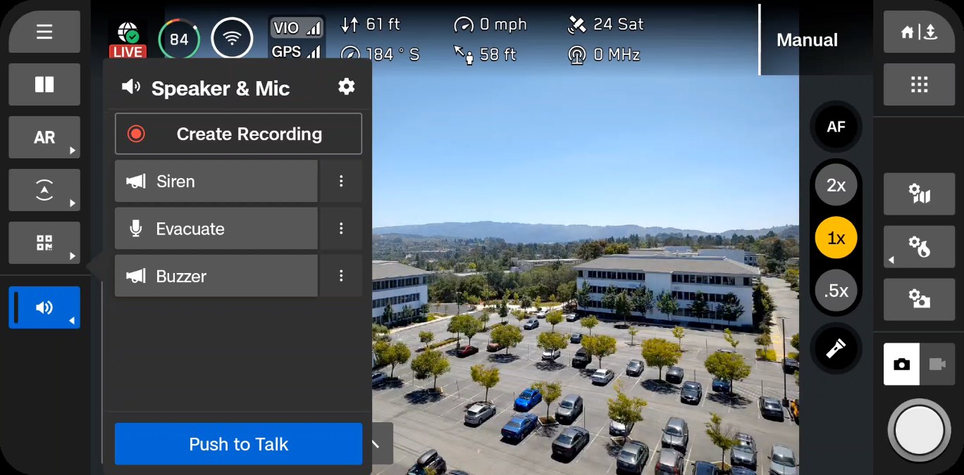
Skydio’s latest update also aims to make the X10 an even more valuable asset for public safety organizations. The drone now supports Speaker and Mic attachments, allowing operators to broadcast live or pre-recorded messages while in flight. This capability is crucial in scenarios like search and rescue operations or delivering announcements during critical incidents.
The update also adds Public Safety Lights to the X10, which can flash in red-and-blue or red-and-white patterns, making the drone more visible during emergency operations.
Improved connectivity and user experience
With the Fly Here Now Updates, the update introduces smoother transitions between the Remote Flight Deck and the physical controller. This allows users to select specific points along the flight path and add transit points for more precise control.
The X10 Controller has been upgraded to v37.1.138 to support multiple users, a feature especially useful for organizations sharing controllers among multiple team members. The streamlined account-switching process facilitates quick handovers during time-sensitive operations.
The software also enables users to share live streams through ReadyLink, using a QR code displayed on the controller, simplifying real-time communication with remote teams.
For better system reliability and battery management — crucial aspects for professional drone operations, Skydio has enhanced its battery estimations by taking into account factors like wind speed, aerodynamics, and power consumption from additional attachments like the Spotlight. These adjustments will provide more accurate return-to-land calculations, helping operators fly with greater confidence.
For those operating in areas with varying connectivity, the update allows users to manually switch between Skydio Connect SL (point-to-point) and Skydio Connect 5G (cellular connection) while in flight, ensuring a stable connection throughout the mission.
Bug fixes and other improvements
The software release addresses several known issues, ensuring a smoother user experience. For instance, image stabilization has been corrected, enabling better performance at higher zoom levels, which was previously a challenge beyond 14x magnification. This improvement is particularly important for high-detail inspections where zoom functionality is critical.
Skydio has also resolved issues related to thermal imaging, enhancing the quality of thermal streams by adapting the bitrate to optimize clarity. The integration of Auto Flat Field Correction (FFC) before flights ensures more accurate radiometric readings, an important aspect for users relying on thermal data.
Additionally, Support Log management has been streamlined with more reliable download and upload progress indicators, helping users engage with support more efficiently. The X10 now retains up to three logs for future uploads, ensuring critical data isn’t lost due to connectivity issues.
For users needing to maintain the integrity of recorded media, the update introduces watermarks that display key information like date, time, drone serial number, and sensor details. This feature supports the authenticity of photos and videos, making them more reliable as evidence in investigations or when shared with stakeholders.
The update also resolves issues that previously caused delays during media sync, especially when using WiFi connections. Now, uploads are faster and more consistent, with better support for modern 11ax routers.
You can see the complete release notes here.
Read more: Cyberhawk unveils AI tool for smarter, faster drone inspections
FTC: We use income earning auto affiliate links. More.


Comments