
GeoCue made a strong statement at INTERGEO 2025 in Frankfurt, unveiling three major innovations. From a new NDAA-compliant aerial LiDAR sensor to immersive 3D visualization features in LP360 software, GeoCue’s latest developments are all about helping drone operators, surveyors, and engineers extract richer insights — and value — from their data.
New NDAA-compliant drone LiDAR sensor
Leading the announcements was the TrueView 641, a new NDAA-compliant aerial LiDAR and imagery sensor that blends long-range, engineering-grade performance with more accessible pricing. With US federal, state, and local contracts increasingly requiring NDAA-compliant hardware, GeoCue’s new system arrives at just the right time for American surveyors and engineering firms looking to stay competitive.
Built in partnership with Triple-IN Laser Technic, a German LiDAR specialist with two decades of field-proven innovation, the TrueView 641 delivers up to 400 meters of range, less than 4 mm accuracy, and a 120° field of view — numbers that easily place it among top-tier systems. It also features an integrated 26 MP global shutter camera and full compatibility with GeoCue’s LP360 drone software, making it a complete package for drone-based mapping missions.
The TrueView 641 delivers precisely what the market’s been asking for: NDAA-compliant, engineering-grade LiDAR that’s both powerful and affordable,” says Frank Darmayan, COO of GeoCue Group.
GeoCue’s Vincent Legrand, VP of global sales, adds that early orders will ship before year-end, noting that the system fills a key gap in GeoCue’s lineup for professionals seeking long-range, precision-grade results in challenging terrain — whether that’s forestry, transportation corridors, or urban environments.
Immersive Image Explorer: Step inside your LiDAR data
Beyond hardware, GeoCue also used INTERGEO to introduce a next-level visualization tool: the Immersive Image Explorer for LP360. This new feature lets users virtually walk through their projects by fusing LiDAR point clouds with captured imagery, creating an environment that feels almost like stepping into Google Street View — except it’s your own dataset.
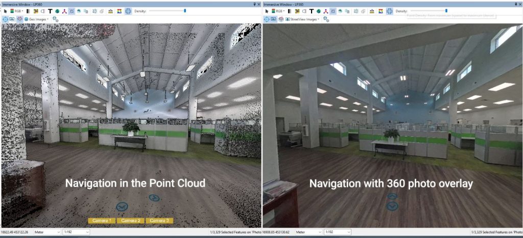
Available in LP360 Drone or Land Standard plans, the Immersive Image Explorer allows imagery from TrueView aerial payloads, mobile mappers, or handheld systems to be overlaid directly behind point clouds. Drone pilots using the DJI Zenmuse L2 or TrueView GO 360 Photo Kit can also take advantage of this new capability.
“The goal is to make complex 3D datasets instantly understandable,” says Darmayan. “With the Immersive Image Explorer, customers can step directly into their data, navigating environments as if they were still on-site.”
For drone mappers, this means quicker validation of coverage, the ability to spot missing areas before leaving the field, and the creation of immersive deliverables for clients. The tool integrates seamlessly into LP360’s existing visualization modes — Map, 3D, and Profile Views — adding a new Immersive View Window that enables real-time navigation from multiple angles.
As Vivien Heriard-Dubreuil, CEO of GeoCue’s parent company mdGroup, put it, “This is more than just a viewer — it’s a smarter way to navigate, validate, and present data. We’re helping professionals work faster, communicate better, and deliver more value.”
LP360 innovations: 3D Mesh and Gaussian Splatting
Finally, GeoCue announced two new add-ons for LP360 that push visualization and modeling even further: the 3D Model Mesh Add-On and the Gaussian Splatting Add-On. These tools turn LiDAR point clouds and imagery collected with the TrueView GO handheld scanner into textured 3D models and ultra-photorealistic renderings, ideal for presentations, design reviews, or virtual inspections.
The 3D Model Mesh Add-On creates high-quality, shareable models directly from LiDAR data, while Gaussian Splatting — a technique recently adopted in visual computing — produces smooth, lifelike representations that traditional meshes can’t match. When combined, they make it possible to generate deliverables that both look better and tell a more complete story of the scanned environment.
“By integrating these tools directly into LP360, we’re empowering professionals to produce richer deliverables and collaborate more effectively,” says Darmayan. For drone users, it’s another step toward turnkey workflows — from data capture to high-end visualization — all within the same ecosystem.
Taken together, GeoCue’s INTERGEO 2025 announcements show a company pushing on all fronts: hardware compliance, visualization, and software innovation. For US drone operators and surveyors, that translates to more flexibility, more compliance-ready options, and more visually powerful results, without needing to stitch together multiple platforms.
As Heriard-Dubreuil sums up, “GeoCue continues to evolve LP360 as the industry’s most complete ecosystem for LiDAR and imagery workflows. Whether on the ground or in the air, we’re helping users see and share their world with greater clarity.”
More: New FCC crackdown could make this your last chance for a DJI drone
FTC: We use income earning auto affiliate links. More.


Comments