For decades, archaeologists knew something extraordinary was hiding beneath the dense rainforests of northern Guatemala. The challenge wasn’t finding clues. It was seeing through a jungle so thick that much of what remained of the ancient Maya world was effectively invisible. Now, a combination of cutting-edge drone technology and LiDAR scanning is helping researchers uncover what may be one of the most important archaeological stories of our time.
The work is taking place in the Mirador Basin, a remote region deep within Guatemala’s rainforest that contains one of the largest concentrations of ancient Maya settlements ever discovered. Led by the Foundation for Anthropological Research and Environmental Studies (FARES), researchers have spent nearly five decades studying the area under the leadership of archaeologist Dr. Richard Hansen.
Their findings are staggering. So far, the team has documented 964 archaeological sites that collectively form 417 ancient cities, towns, and villages. At the center of the basin sits El Mirador, considered one of the largest ancient cities in the Western Hemisphere and a key site for understanding how complex societies emerge, thrive, and eventually collapse.
But reaching these sites is anything but easy. Many locations are buried beneath triple-canopy rainforest and require a two- to three-day trek from the nearest road. Traditional archaeological surveys can take months or years. Even satellite imagery struggles to reveal what’s hidden beneath the thick vegetation.
That’s where drones are changing the game.
New: These 11 UAS have escaped the FCC’s foreign drone ban
FARES has long been a pioneer in aerial archaeology, using manned aircraft LiDAR surveys in 2015 and 2018 to reveal the vast scale of Maya infrastructure across the basin. Those missions transformed researchers’ understanding of the region, exposing sprawling urban networks, monumental architecture, and extensive causeways connecting settlements.
Today’s technology is pushing those discoveries even further.
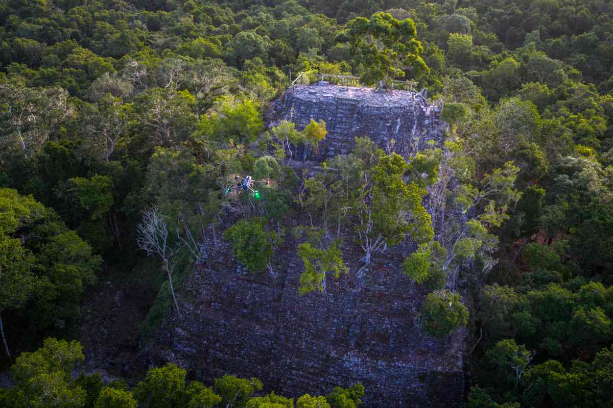
The team is now using DJI Enterprise’s newest combination of hardware, including the DJI Matrice 400 drone and Zenmuse L3 LiDAR payload. According to Hansen, the difference compared to earlier systems is dramatic.
Instead of flying high and fast like traditional aircraft, drones can fly lower and slower, collecting significantly more detail. The latest setup also allows researchers to cover larger areas from a single launch point while capturing far richer information beneath the canopy.
The Zenmuse L3’s ability to collect 16 returns per laser pulse — compared to just five on previous-generation systems — gives archaeologists a much better chance of detecting the ground through layers of vegetation. Every additional return increases the odds of identifying structures hidden below.
Once the data is collected, another transformation begins. Dr. Edwin Escobar oversees the process of turning billions of LiDAR points into usable archaeological maps. Specialized software removes trees and vegetation from the dataset, creating highly detailed digital elevation models of the landscape below.
The results can be astonishing. Pyramids, staircases, causeways, plazas, and previously unknown structures suddenly emerge from what appears to be untouched rainforest. Features that are invisible from the ground, and often impossible to spot from satellites, become unmistakable.
For archaeologists, this isn’t just about producing prettier maps. It’s about understanding how an entire civilization functioned. New scans are helping researchers identify settlement patterns, transportation networks, and architectural complexes that may reshape existing theories about Maya society.
Perhaps the most remarkable claim from the project is that these maps may become a permanent record of the basin. Hansen believes the precision and accuracy now achievable with modern drone-based LiDAR are so high that future generations of researchers may never need to remap the region at this scale again.
In an era when drones are often associated with deliveries, inspections, or defense applications, the Mirador Basin project offers a different perspective. Here, the technology is helping uncover humanity’s past. And beneath a rainforest that has guarded its secrets for more than a thousand years, those secrets are finally coming into view.
New: DJI Pocket rival? Insta360 unveils Leica-powered Luna Ultra camera
FTC: We use income earning auto affiliate links. More.


Comments