DJI’s flagship drone‑mapping software, Terra, has just leapt to version 5.0 — and the update is every bit as substantial as its round‑number suggests. The headline feature is native support for 3D Gaussian Splatting, a next‑generation rendering technique that turns standard photographs into richly detailed, life‑like digital twins in a fraction of the time required by traditional photogrammetry. The new release also debuts an overhauled interface, fresh export options, upgraded hardware support, and a friendlier licensing model, making Terra’s toolset more accessible to surveyors, filmmakers, civil engineers, and public‑safety teams alike.
Why 3D Gaussian Splatting matters
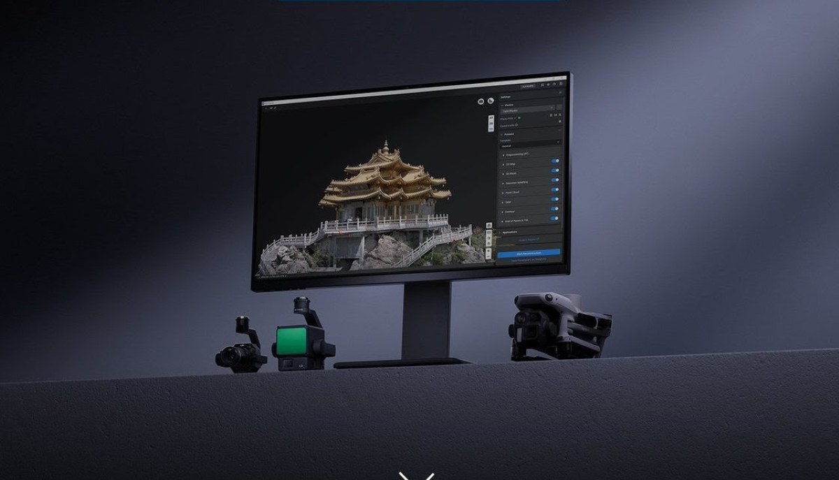
Gaussian Splatting represents each pixel as a tiny 3D Gaussian “blob” and optimizes their collective arrangement to approximate both geometry and colour. This approach excels at representing fine edges, reflective or transparent materials, intricate vegetation, and other scenes that stump classic mesh‑plus‑texture pipelines. DJI says the method produces distortion‑free orthomosaics in addition to 3D models, giving surveyors clean 2D and 3D outputs from a single workflow.
In DJI Terra, splat processing runs on‑device (it is not a cloud service) and supports both 2D and 3D deliverables. Results are written to a new “<project>/3dgs/results” folder in three industry‑friendly formats:
- 3DTiles (Terra’s own LOD schema, viewable in Cesium)
- PLY for universal 3D exchange
- GeoTIFF for GIS orthomosaics
The first‑generation implementation does not yet handle cluster reconstruction or in‑app annotations, but a Cesium viewer plug‑in is already on DJI’s roadmap.
A cleaner UI and two product tiers
Version 5.0 sports a fully redesigned interface with reconstruction “parameter templates” that pre‑fill common settings, cutting setup time for novice users while still letting power users dive deep. DJI has also rationalized its SKUs:
- Standard, the baseline edition, free upgrade for legacy Survey/Pro licensees
- Flagship, adds Gaussian Splatting and ships as a no‑cost upgrade for Electricity‑edition customers; Cluster users inherit all Flagship features automatically
Holders of permanent Terra 5.0 keys can move to the latest build without paying a maintenance fee.
New capture sources and export pipelines
Beyond Gaussian Splatting, Terra 5.0 broadens input and output flexibility:
- Orthophoto‑based 2D mapping from the Matrice 4T — ideal when only visible‑light stills are available.
- Detailed Inspection projects now accept imagery from DJI Matrice 4T, 4D, 4TD, and 4E drone platforms — bringing high‑resolution façade analysis and asset‑management to the newest airframes.
- FBX mesh export for direct ingestion into engineering, VFX, and game‑development software.
- LAZ point‑cloud export, shrinking storage footprints versus LAS without quality loss.
- Japan’s JPGEO2024 elevation system joins the list of supported coordinate frameworks.
Collectively, these changes make it easier to push Terra data downstream — whether that’s a Cesium web viewer, a BIM pipeline, or a Unity game scene.
Performance and hardware upgrades
DJI has taken the opportunity to refresh Terra’s engine under the hood:
- LiDAR‑to‑2D ortho reconstructions now run 20–50% faster, depending on workstation specs.
- RTX 50‑series ‘Blackwell’ GPUs are officially supported, unlocking the high‑bandwidth memory and AI cores of NVIDIA’s 2025 flagship cards.
- Model visual clarity has been sharpened, and the GCP (ground‑control‑point) page opens more quickly.
- Users can switch the output coordinate system from the task‑page footer without restarting a project (visible‑light aerotriangulation excepted).
Gaussian Splatting itself demands Windows 10/11 64‑bit, 32 GB RAM, and a GPU with compute capability 6.1 or higher (4 GB VRAM minimum, 8 GB recommended).
Smarter agriculture, clearer deliverables
On the analytics side, DJI has retrained Terra’s machine‑learning models for precision agriculture. The software now more accurately separates fruit trees, buildings, utility poles, water bodies, bare ground, and other classes — laying the groundwork for better yield estimation and land‑use reporting.
Maintenance patches already rolling out
A day after 5.0.0 landed, DJI shipped version 5.0.1, resolving a bug that prevented offline (air‑gapped) licenses from upgrading during the free‑iteration window. The rapid follow‑up indicates DJI plans to iterate quickly on its new splatting engine — good news for users eager to see annotation, measurement, and cluster processing added back in.
Terra’s evolution mirrors a broader trend: bringing emerging academic vision research straight into practical field tools. For survey and inspection teams already flying Matrice‑series drone platforms, Gaussian Splatting promises faster processing, sharper edges, and fewer artefacts — especially on glass, power‑lines, and foliage — without an expensive lidar payload. Architectural visualizers gain a one‑click route to FBX meshes; city planners can sling 3DTiles straight into Cesium for web‑based stakeholder demos; and agricultural consultants see more reliable ML classifications. Throw in leaner point‑cloud storage, better coordinate‑system handling, and complimentary license upgrades, and Terra 5.0 feels less like an update and more like a relaunch.
More: Three new DJI drones just dropped — but not for you
FTC: We use income earning auto affiliate links. More.


Comments