If there’s one thing construction teams everywhere can agree on, it’s this: visibility is everything. And now, DroneDeploy is doubling down on that idea through a new partnership with Cairn Homes — Ireland’s leading homebuilder — to bring advanced drone reality capture tech across more than 25 residential developments. The goal? Make construction smarter, safer, and far more data-driven.
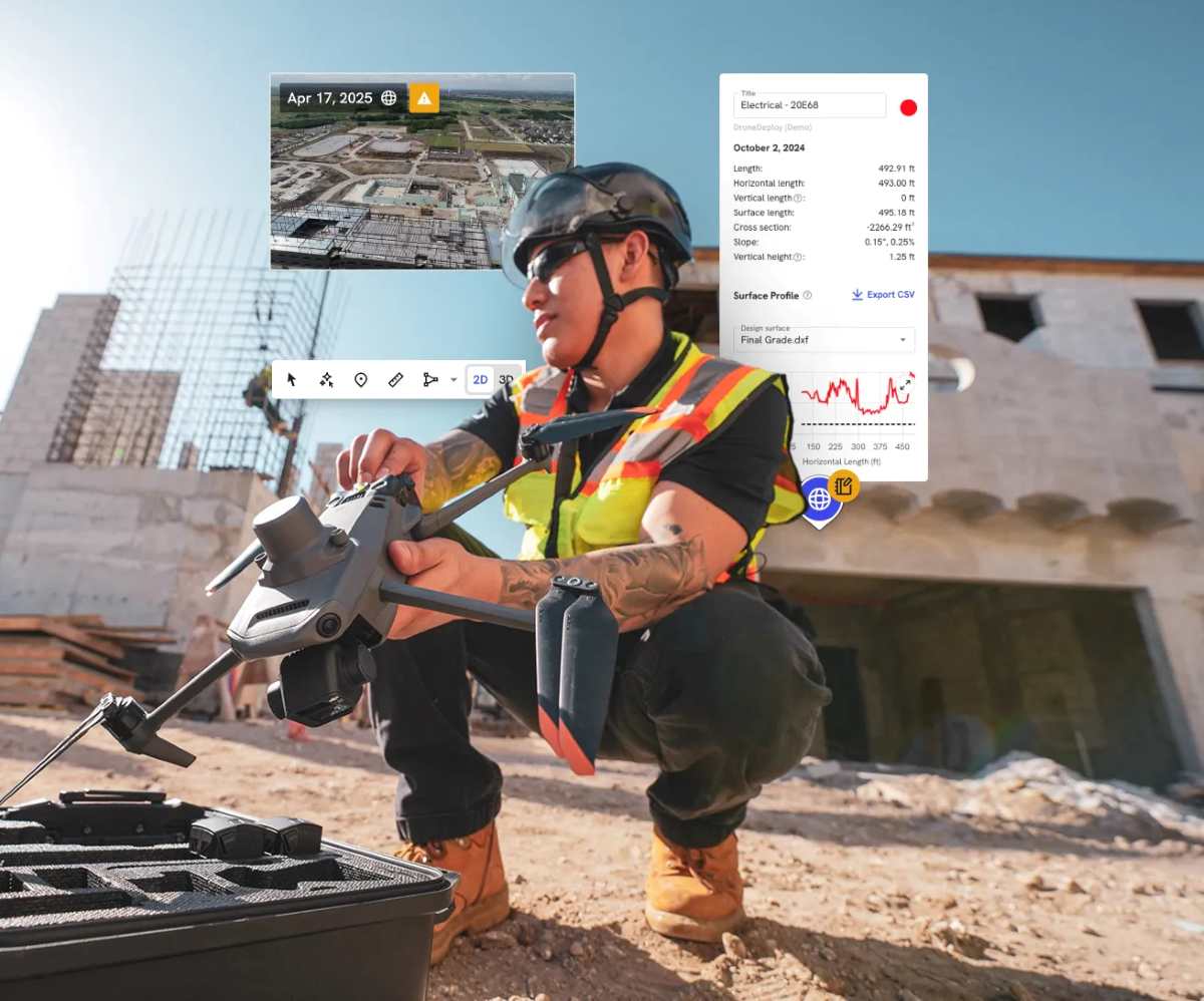
DroneDeploy, which says its platform has been used across more than three million sites globally, is helping Cairn unify how it captures and uses visual data, from the air and the ground. Instead of siloed workflows, teams now rely on a single system that combines drone mapping, 360-degree imagery, and handheld 3D scanning.
And it’s not just a pilot anymore. In under two years, Cairn has scaled from early testing to a full enterprise-wide rollout, embedding reality capture into its day-to-day operations. That shift is already changing how projects are managed. Teams across site management, engineering, planning, aftercare, and commercial operations are using the platform to capture high-resolution site data and turn it into actionable insights. Everything from early-stage site assessments to design verification and ongoing progress tracking is now backed by visual data.
One of the biggest advantages is having a single, continuously updated visual record of each project. Drone maps and 3D models are used throughout the entire lifecycle, from initial design and earthworks to final handover plans. By overlaying construction drawings directly onto real-world imagery, teams can better plan crane placements, haul routes, and temporary works, reducing costly clashes and rework.
But the real breakthrough may be happening underground. Cairn is now using DroneDeploy’s 3D scanning tools, combined with RTK-enabled mobile capture, to document trenches before they’re backfilled. That means utilities and underground services — often hidden and hard to verify later — are now captured in permanent, measurable records. Teams can check installation depth, spacing, and quality long after the work is completed.
New: Drone survey without GCPs? Wingtra claims sub-3 cm accuracy
It’s a big step toward solving one of construction’s long-standing blind spots. At the same time, Cairn is exploring how artificial intelligence can take things even further. By testing DroneDeploy’s Progress AI, the company is automating site monitoring in a way that goes beyond traditional reporting. The system analyzes visual data from routine walkthroughs to track installation progress and compare it against project schedules.
In practical terms, that means teams can spot delays earlier and make decisions with greater confidence, all based on consistent, data-driven insights rather than manual updates.
DroneDeploy sees this as a sign of where the industry is heading. According to Michael Bernatz, the company’s territory director for EMEA, Cairn isn’t just experimenting with new tools; it’s operationalizing them at scale. By bringing aerial mapping, ground capture, and AI into a unified platform, the builder is reducing risk, improving coordination, and giving stakeholders a clearer picture of what’s happening on-site.
For Cairn, the move is part of a broader digital construction strategy. Jakub Urbanczyk, the company’s digital construction manager, says the technology has fundamentally changed how teams plan and deliver projects. With all visual site data in one place, teams can track progress at a granular level — down to individual homes or apartments — while also verifying earthworks, coordinating logistics, and improving overall accuracy. And with ongoing pilots in 3D scanning and AI-powered analysis, the company is continuing to refine how data flows into its broader business systems.
Taken together, the partnership highlights a growing trend in construction: the shift from reactive problem-solving to proactive, data-driven decision-making. And if Cairn’s rollout is any indication, reality capture isn’t just a nice-to-have anymore; it’s quickly becoming the backbone of modern construction workflows.
More: FCC eyes sweeping reforms to boost US drone power
FTC: We use income earning auto affiliate links. More.


Comments