From ancient ruins to hometown streets, some places deserve to last forever. That’s the idea behind Antigravity’s new global initiative, Project Eternal, which asks drone pilots and 360-degree camera users worldwide to help document the world before it changes.
At a time when drone buyers often focus on specs like battery life, obstacle sensing, or camera resolution, Project Eternal gives the conversation a different angle: what if a lightweight consumer drone could help save history? That idea sits at the center of Antigravity A1, a sub-250-gram drone built around 360-degree capture. Antigravity is now pushing the A1 as a tool for creators, historians, architects, and everyday users who want to document the world in immersive detail.
Project Eternal is built around two major goals. The first is preservation without disruption. Traditional methods of documenting heritage sites can involve bulky scanning rigs, multiple camera setups, or equipment that may be difficult to use around fragile environments. Antigravity says the compact A1 drone can gather high-fidelity imagery while minimizing physical intrusion, allowing sensitive locations to be recorded with less impact. At the same time, Insta360 camera users can digitally capture meaningful places from the ground level before they are lost to time, weather, or development.
The second mission is making advanced 3D creation easier for everyone. Antigravity says it is combining panoramic imaging technology with its 360 imaging system to create a seamless air-to-ground workflow capable of full-sphere capture in a single pass. In simpler terms, users can capture a place from above and around it, then turn that footage into interactive digital environments.
To help make this happen, the company has partnered with 3D Gaussian Splatting platform Splatica. Gaussian Splatting is one of the hottest trends in digital reconstruction right now, allowing real-world footage to be transformed into realistic, navigable 3D scenes. Antigravity says the campaign will include 1,000 free 10-minute uploads, giving users a low-friction way to experiment with turning drone or panoramic footage into immersive models.
This is where things get interesting. Most drone launches promise better selfies, cleaner travel footage, or smoother tracking shots. Antigravity is leaning into a different use case: linking consumer drones with the future of digital twins, virtual tourism, and preservation tech.
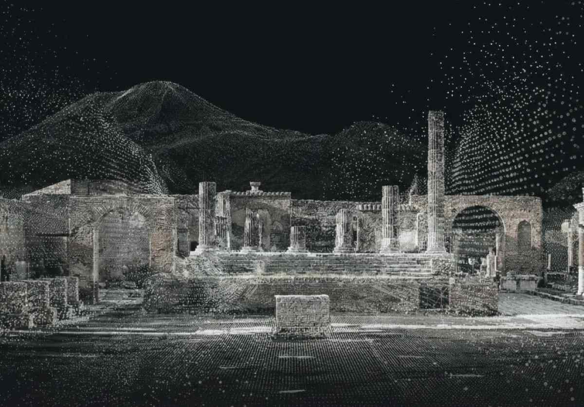
As part of Project Eternal, Antigravity is also working with CyArk, a respected nonprofit known for digitally preserving world heritage sites. Their first pilot project will focus on two iconic locations in Italy: Civita di Bagnoregio and Pompeii.
Civita di Bagnoregio, often called the “Dying City,” is famous for its dramatic erosion risks and shrinking land base. Pompeii, meanwhile, remains one of the world’s most extraordinary archaeological records after being preserved under volcanic ash nearly 2,000 years ago. By creating high-fidelity digital models of both sites, Antigravity hopes to show how modern imaging tools can preserve places that are simultaneously fragile and globally significant.
The company is also inviting creators worldwide to join in. Influencers and digital artists are expected to build 3D recreations of destinations ranging from Roman theaters to Jeju Island, then share the process across social platforms.
There is also a public campaign built around a simple prompt: If you could preserve one place forever, what would it be? That question opens the door beyond archaeology. Users could document a family farm, neighborhood basketball court, hometown street market, old school building, or natural trail with personal meaning. In that sense, Project Eternal is not just about famous ruins — it is about everyday memory.
More: 25 new DJI launches blocked by FCC, $1.5 billion at stake
FTC: We use income earning auto affiliate links. More.


Comments