
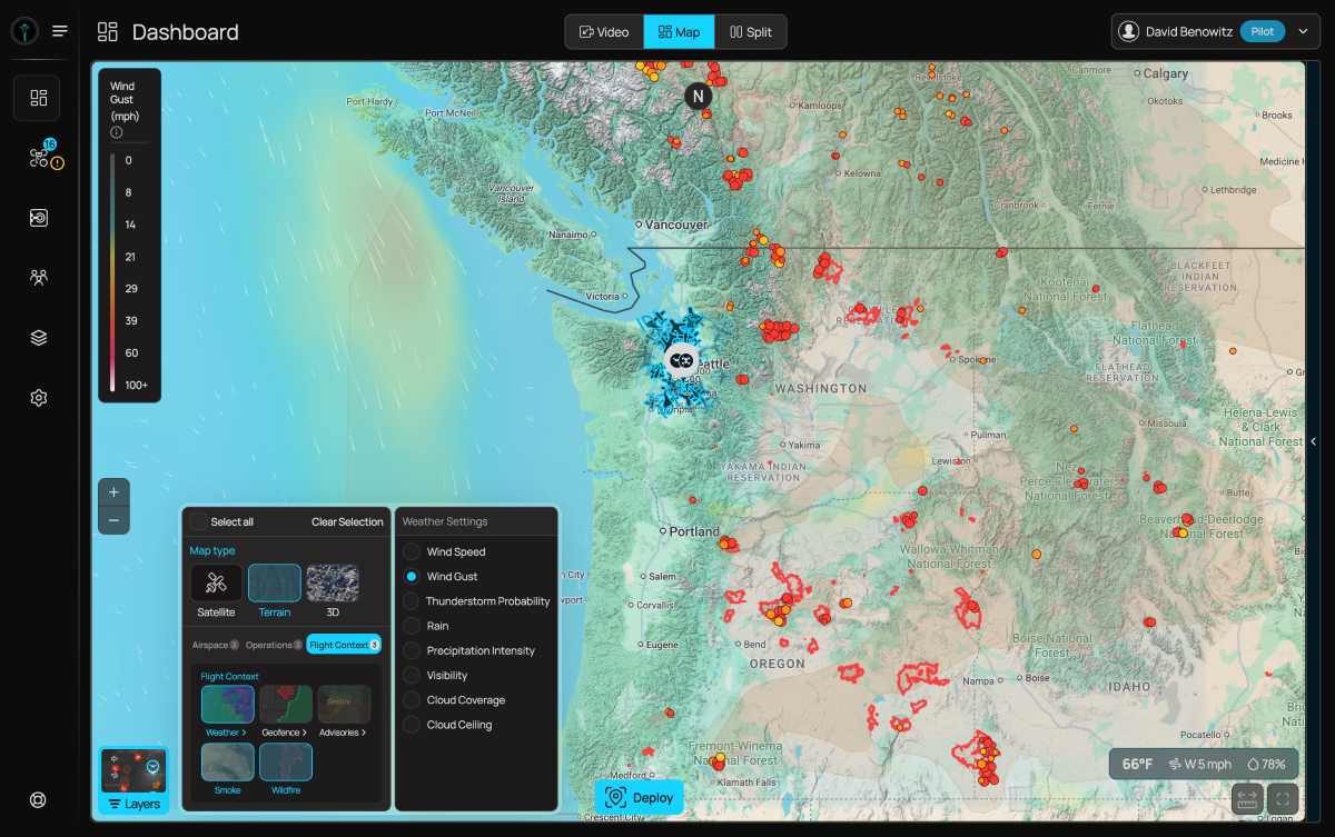
Wildfire response can get complicated fast. There are drones in the air, crews on the ground, dispatch information coming in, and, increasingly, huge areas of smoke making it harder to see what is happening. BRINC is now trying to put at least one more piece of that puzzle in the same place.
The public safety drone company has added two new map layers to its LiveOps platform, giving agencies real-time information on active wildfires and smoke conditions without requiring another application or screen. The layers became available to all BRINC customers on August 7 at no additional cost.
What makes the rollout particularly interesting is how quickly it came together. The feature reportedly started as an engineer’s prototype, built while he was tracking fires ahead of a camping trip. Within days, it had gone from a personal tool to a capability available to every agency running LiveOps.
The timing was deliberate. With agencies across the US West actively battling wildfires, BRINC wanted to get the information into responders’ hands immediately. Fire detections and smoke conditions now appear directly on the same map as an agency’s drone operations, with each layer independently toggleable.
The new features use data from the National Oceanic and Atmospheric Administration (NOAA), displaying fire detections and smoke coverage directly on the map that agencies already use for drone operations, live video, and incident response.
For fire departments and emergency managers, the additional data could provide another way to understand where fire activity is occurring and how smoke is affecting an area. Law enforcement agencies could also use the smoke information when visibility becomes an issue during operations in communities affected by wildfires.
And the appeal is pretty simple: responders don’t have to keep jumping between different systems.
“When agencies are stretched thin responding to wildfires, the last thing they need is another screen to check,” says BRINC founder and CEO Blake Resnick. “Our customers already run their drone operations in our software. Now fire activity and smoke conditions are right there on the same map.”
The NOAA data being incorporated into LiveOps includes satellite-based fire detections and smoke plume information. NOAA’s fire and smoke products are already used in federal wildfire and air-quality monitoring, although satellite-based detections can have limitations when clouds, smoke, or nighttime conditions interfere with observations.
BRINC says the move is part of a broader effort to turn LiveOps into a single operational view rather than simply a place to manage drones. The platform can bring together drone video, dispatch information and third-party data. Customer requests have also driven previous additions, including Google Maps traffic data for agencies that need to understand road conditions during pursuits and other incidents.
The company says those upgrades and core integrations are included for customers at no additional cost. That’s potentially significant as public safety agencies increasingly use drones as another set of eyes during emergencies. BRINC says more than 1,000 public safety agencies and more than 20% of US SWAT teams use its technology.
With wildfire response becoming an increasingly data-heavy operation, putting fire activity, smoke conditions and drone video on the same screen could make that information a little easier to act on.
More: FCC isn’t done tightening the screws on foreign drones


FTC: We use income earning auto affiliate links. More.




Comments