Microsoft is offering a preview of its new AI-powered simulator for drones, flying taxis, and other advanced aerial mobility (AAM) vehicles. Project AirSim can be used to build, train, and test autonomous drones through hyper-realistic simulations of real-world scenarios. The goal is to help drone makers encode autonomy without the need for deep expertise in AI.
Project AirSim is a result of five years of research and experimentation into deep learning and AI. While the earlier open-source research project is being retired, Microsoft said learnings from the same have inspired the launch of this new end-to-end platform that would allow AAM customers to test and train AI-powered aircraft in simulated 3D environments more easily.
Read: Skydio’s secret sauce for making drones smarter, faster is now public
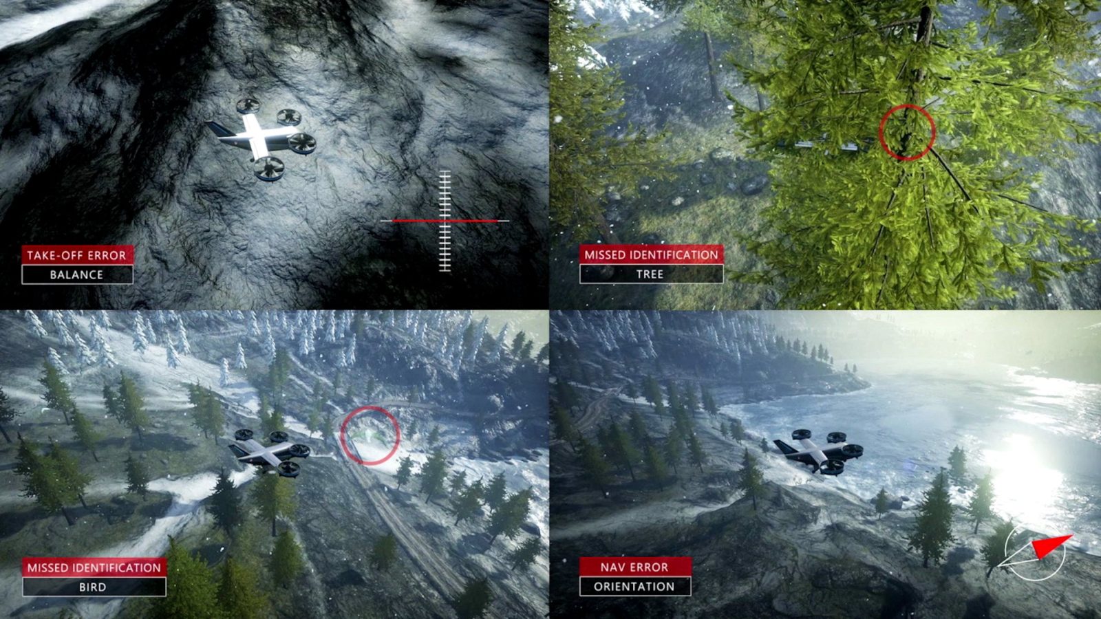
Massive amounts of data are required for training drone AI models on exactly which actions to take at each phase of flight, right from takeoff to cruising and landing. Using Project AirSim’s high-fidelity simulations, drone AI models can run through millions of flights in seconds, learning how to react to countless variables much as they would in the physical world:
How would the drone fly in rain, sleet, or snow? How would strong winds or high temperatures affect battery life? Can the drone’s camera see a turbine’s arms on an overcast day just as well as on a clear one?
Gurdeep Pall, Microsoft’s corporate VP for business incubations in technology and research, explained:
Autonomous systems will transform many industries and enable many aerial scenarios, from the last-mile delivery of goods in congested cities to the inspection of downed power lines from 1,000 miles away. But first, we must safely train these systems in a realistic, virtualized world. Project AirSim is a critical tool that lets us bridge the world of bits and the world of atoms, and it shows the power of the industrial metaverse – the virtual worlds where businesses will build, test, and hone solutions and then bring them into the real world.
Read: Tiny planes, big planes – Wing unveils new drones for different delivery markets
Using data from Bing Maps and other providers, Microsoft is curating a ready-to-use library of simulated 3D environments of both urban and rural landscapes under Project AirSim. This library would be able to pull up specific locations, like New York City or London, or generic spaces, like an airport.
In addition, the company plans to make pre-trained AI models available for specific scenarios also, such as drone infrastructure inspection, delivery and logistics, and urban air mobility.
One of the early testers of Project AirSim is North Dakota-based drone startup Airtonomy. The company used AimSim simulations to train its autonomous drones that are now inspecting wind farms, surveying wildlife, and detecting leaks in oil tanks across the Midwest.
Airtonomy CEO Josh Riedy said each AI-powered flight that the company’s drones undertake first happened countless times in simulated 3D worlds. Here’s what Riedy said:
You don’t want to fly drones into wind turbines, powerlines, or really anything for that matter. Coupled with the fact that winter can literally last 7 months in North Dakota, we realized we needed something other than the physical world to design our solutions for customers.
Microsoft said it is working closely with other industry partners as well to extend accurate simulations to weather, physics, and – crucially – the sensors an autonomous drone uses to “see” the world.
Read: Wait, why is NASA flying drones in dense fog?
Gathering all this data by themselves is impossible for any single drone manufacturer.
As Matt Holvey, director of intelligent systems at aviation pioneer Bell, pointed out, you can’t afford to make millions of mistakes in the real world. “Often, you can’t afford to make even one.”
This is why Bell is using AirSim to train its AI model on thousands of “what if” scenarios in a matter of minutes, helping it practice and perfect a critical maneuver before attempting it in the real world.
More recently, the company used Project AirSim to prepare for NASA’s Systems Integration and Operationalization (SIO) extension project, which aims to accelerate the use of autonomous aircraft in the national airspace system. The company’s Autonomous Pod Transport (APT) aircraft flew through a corridor in the Dallas-Fort Worth area, successfully demonstrating the craft’s ability to maintain contact with ground-based radar monitoring systems.
In the meantime, the Project AirSim team is actively engaged with standards bodies, civil aviation, and regulatory agencies in shaping the necessary standards and means of compliance to accelerate the drone industry.
Microsoft also plans to work with global regulators on how Project AirSim might help with the certification of safe autonomous systems. The platform can be used to create potential scenarios that an autonomous vehicle must successfully navigate. In one case, a flying taxi could be faced with blinding rain. In another, it must navigate deep winds. Yet another scenario could test the aircraft’s response in case of loss of GPS connectivity. But if the vehicle could still get from Point A to Point B every time, that could be an important step toward certification.
Read: Blueprint for integrating autonomous air taxis into the national airspace system
FTC: We use income earning auto affiliate links. More.


Comments