Swiss drone maker Wingtra has launched new drone data planning and collaboration software, WingtraCLOUD, emphasizing on several time-cutting and user-friendly features.
Wingtra says its new offering will simplify drone data collection and streamline the onboarding of surveyors and pilots. More importantly, WingtraCLOUD will help to replace many different software tools with one environment and provide an intuitive experience that goes beyond mere technical execution. The aim is to remove the complexity of managing and using advanced technologies and minimize errors that fragmented workflows tend to introduce.
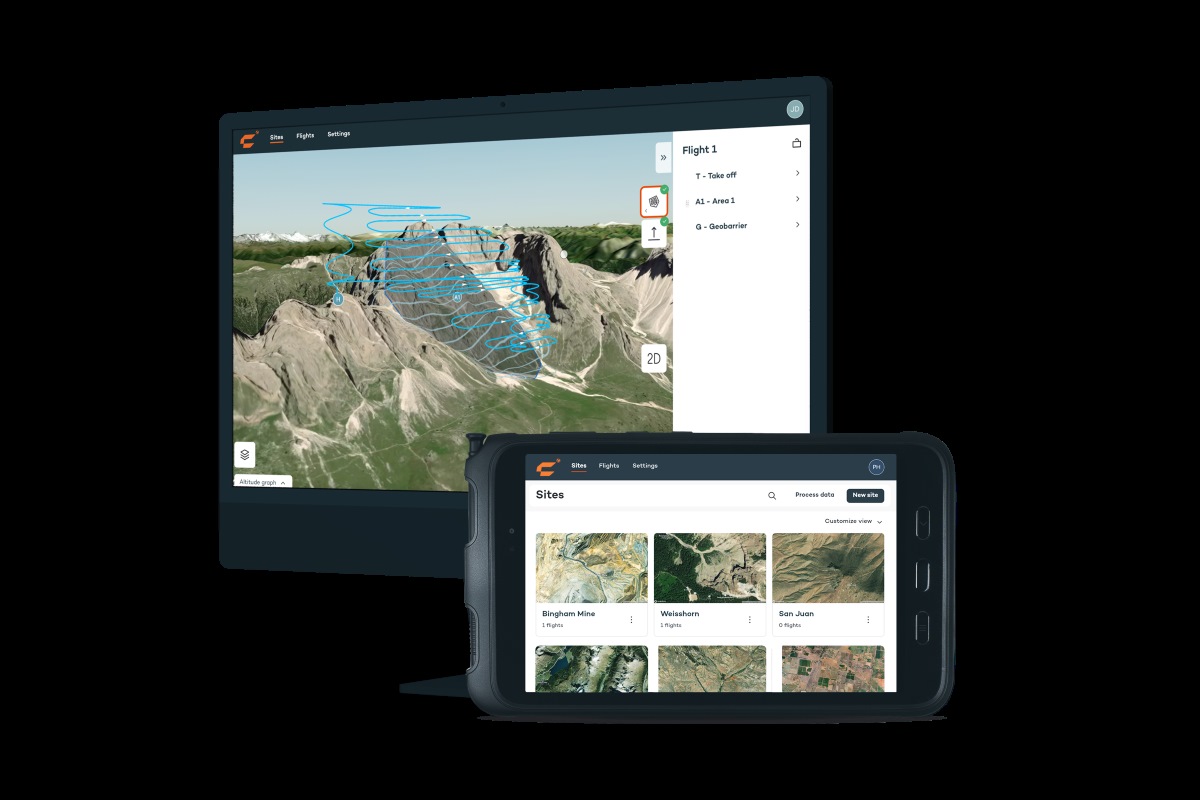
With WingtraCLOUD, site managers can plan complex areas and delegate flights to less-experienced surveyors. Changes made by these surveyors in the field can be immediately evaluated by managers. Progress updates are available in real-time, allowing higher-level stakeholders to sync and check project status from anywhere in the world without waiting for time-zone-aligned calls.
Also read: New DJI policy: No flight record sync for US drone pilots
“We’ve spoken with customers across a range of sectors working for the most successful yet pressurized companies in their industries,” says Philip Santa, lead UX designer at Wingtra. “We’ve taken their feedback to heart and blended it with the expertise of dozens of engineers to bring ease of use to the next level. The result is very exciting, as WingtraCLOUD offers what we see as the most intuitive, engaging, and value-add software on the market today.”
Here are some of the features that the company feels would help it stand out from the competition:
- Avoiding version control issues by allowing any permitted stakeholder to access any project from anywhere, anytime
- Organizing flights and files intuitively according to projects, enabling quick access to the latest insights with one click
- Empowering even junior pilots to fly with confidence and precision using direct import of background maps and simple 3D flight features
- Ensuring no re-flights or surprises in data through preflight accuracy checks and intuitive elevation graphs with color-coded GSD and AGL height indicators
- Fly with confidence knowing that your base station and checkpoints are set up thanks to a ground-setup pre-flight assessment feature
- Optimizing ground setups with preflight confirmations using WingtraCLOUD planning tools
- No coordinate transformation hassles; you can set the specifications for the site and WingtraCLOUD will automatically apply them
Marcos Bayuelo, EVP of product at Wingtra, says, “WingtraCLOUD not only streamlines workflows for surveyors but also opens the door to way more adoption of aerial data capture across industries and for all sizes of business. From enterprises to engineering firms to service professionals, this software is a game-changer that improves safety while making resource and asset management much more precise and efficient.”
Request early access to the software here.
Read more: How Anzu Robotics is making DJI drone replicas for US
FTC: We use income earning auto affiliate links. More.


Comments