One-click drone 3D modeling specialist SkyeBrowse is inching closer to its ultimate vision – being able to create accurate 3D models in real-time. The Texas-based company has boosted its processing speed by up to 1.5x and introduced the highly-requested GPS Tool.
SkyeBrowse’s technology is designed to dramatically improve situational awareness, strategic planning, and overall safety for various industries, but especially public safety and emergency response. Imagine a SWAT team being able to generate a 3D model of a building’s interior as they’re entering it, or firefighters mapping out a burning structure as they navigate through it.
For disaster response and urban planning, accurate and immediate damage assessment can lead to quicker and more effective recovery efforts. In construction and real estate, the technology could facilitate instant progress tracking and virtual property tours.
Traditionally, laser scanners have been used for 3D modeling, but they are expensive and cumbersome, often costing tens of thousands of dollars. Moreover, these systems require specialized training and are less effective in certain environments, such as smoke-filled rooms or areas with reflective surfaces.
SkyeBrowse helps to overcome these limitations by utilizing devices such as smartphones or drones, making 3D modeling more accessible and flexible. The company’s patented videogrammetry technology processes 100 times more data than traditional photogrammetry methods, reducing processing times from hours to minutes. And now, 3D models process up to 1.5x faster and more accurately than ever.
Also see: Autel Robotics unveils new EVO Lite Enterprise drone series
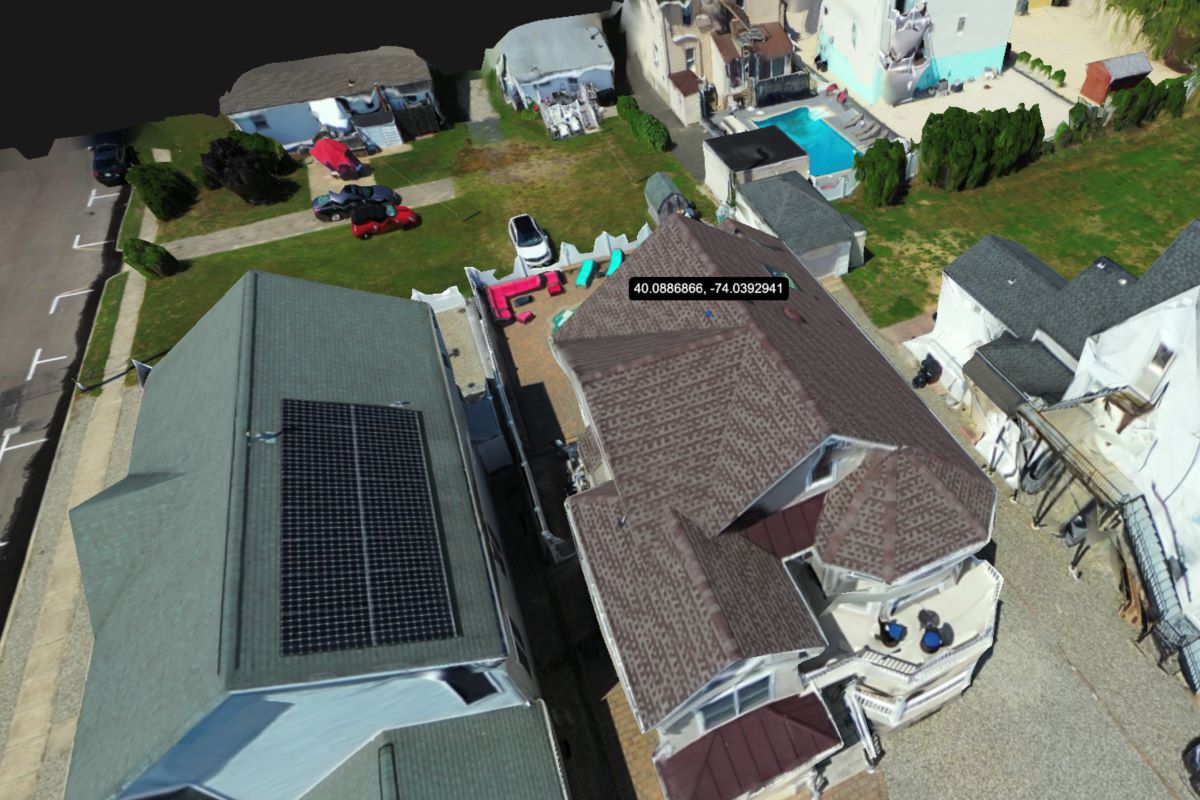
The new GPS Tool allows users to pinpoint exact locations on the 3D models. It enables accurate measurements and enhances coordination between field teams and remote analysts. This tool is available to all subscribers with varying levels of accuracy:
- Premium subscribers get 0.25 inches of accuracy
- Lite subscribers get 2 inches of accuracy
- Freemium users get 6-12 inches of accuracy
The SkyeBrowse platform will now show you an upload box for GPS whenever you upload a video for Universal Upload or Interior Mapping. Simply drag and drop or choose a file from the pop-up. The system accepts all subtitle files from DJI and Autel drones (except for Autel Max 4T).
Read more: DJI Neo retail box leak reveals all: 135g drone, 4K video, AI subject-tracking
FTC: We use income earning auto affiliate links. More.


Comments