The Bondgate Tower in Northumberland, UK, is a 15th-century monument that is in danger of collapse, and as such, sits on the “Historic England’s Heritage At Risk” register. As part of conservation efforts, the historic gatehouse was recently mapped using a drone, and the results are so incredible, you need to see them for yourself.
The aerial survey was conducted in less than a day, requiring only two flights, and without installing a scaffold structure – thereby saving time and money. Three Sixty Group conducted the survey on behalf of the Northumberland Estates, the tower’s custodians. UK-based drone supplier Heliguy provided the surveyors with DJI M300 RTK and Zenmuse P1 photogrammetry camera for the mapping mission.
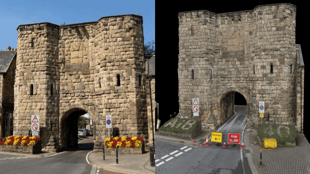
The image above shows just how detailed the digital representation is, compared to its real-life counterpart (left). But we’d encourage you to view the 3D model in super-high-resolution right here.
Also read: DJI drops major firmware update for M300 RTK drone
As Heliguy points out in a blog post detailing the project, the DJI P1 camera is an incredible addition to the drone surveying market. Its 45MP full-frame sensor collects high-resolution data and increases mapping efficiency by capturing more data in each shot.
The quality of the DJI P1 camera has helped to build a 3D model, which is bordering on reality capture – hugely beneficial for inspectors conducting analysis remotely or back in the office. This is the kind of quality that is needed to ensure that a digital model is helpful for up-close inspection.
Even more significantly, the level of detail never wanes when zooming in on sections of the wall, as you’d notice in the link to the 360-degree model above as well as in the images below. This up-close clarity is especially important for the Bondgate Tower as its deteriorating condition has been primarily caused by high-sided vehicles colliding with the archway.


Experts will now use the 3D model to conduct condition-based inspections and to shape a program of maintenance and repairs. It will also serve as a valuable asset for heritage documentation.
Kyle Hodgson, chief surveyor for the project, sums up:
The drone reduced the need for access platforms and rope access, meaning it was a lot safer and quicker to collect the data, and allowed me to capture areas of the building which might not have been possible using alternative methods. The drone was also able to provide multiple angles, covering various perspectives, to ensure a robust model was built to provide a full review of the whole structure. Traditional methods tend to only provide one angle from the ground up, or involve serious manpower and a laborious workflow to cover multiple angles.
Read more: DJI Terra software update makes drone mapping smoother, faster
FTC: We use income earning auto affiliate links. More.


Comments