So, you use DroneDeploy to visualize and analyze your Skydio drone data? You can now upload imagery captured on any Skydio drone directly to the DroneDeploy cloud platform without ever touching your SD card!
This super cool functionality, that bypasses manual upload and sorting processes altogether, has been made possible through integration between Skydio Cloud and DroneDeploy. And to access it, you will require a DroneDeploy Teams or Enterprise subscription, as well as subscriptions to Skydio Cloud and 3D Scan.
How does the Skydio, DroneDeploy integration work?
Skydio Cloud gives enterprise customers a way to upload and manage their flight media using a feature called Skydio Sync over Wi-Fi. The same feature will now allow you to identify and select which scan data you’d like to import into DroneDeploy to create high-resolution 2D orthomosaic maps and 3D models.
Also read: Skydio makes a move on filmmakers with KeyFrame autonomous drone cinematography
Any Skydio flight within a 10-kilometer radius of your DroneDeploy project will appear as an option for upload within DroneDeploy. As the screengrab below illustrates, you simply check a box to select which scans you’d like to upload to your project, instead of manually categorizing, importing, and re-categorizing this data.
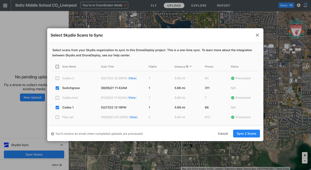
Once the import is complete, DroneDeploy will process the images into high-resolution maps and models.
Clearly, this new workflow is designed to save time, while avoiding the hassle of SD cards and manual data upload processes. As Erik Till, a senior product marketing manager at Skydio, explains:
The data captured by drones is invaluable, but making it available to the right teams for analysis in a timely manner is key to getting the most out of it. Keeping track of SD cards, sorting folders, and performing manual uploads is not only cumbersome, but also slows down operations, leaves room for mistakes, and keeps people from focusing on the more important task of performing data analysis to make well-informed decisions.
If you’re a customer of Skydio 3D Scan, then you’re already enjoying best-in-class, automated data capture that the software makes easier and faster than previously possible. With the new DroneDeploy integration, your job just got even easier.
Read more: AirData partnership enables automatic retrieval of Skydio drone flight data
FTC: We use income earning auto affiliate links. More.


Comments