DJI is doubling down on drone software. And this time, it’s targeting one of the most overlooked parts of the drone mapping workflow: how 3D data is actually viewed and shared.
The company has officially launched DJI Reality, a new 3D model viewer integrated into DJI Terra. While it may sound like a simple add-on, the move signals something bigger: DJI is trying to own the entire pipeline, from data capture to final presentation. And here’s the kicker: it’s completely free.
A free tool that tackles a costly problem
For years, drone mapping workflows have been fragmented. Data captured by drones gets processed in one tool, edited in another, and then shared through yet another platform, often adding cost and complexity at every step. DJI Reality is designed to eliminate that friction.
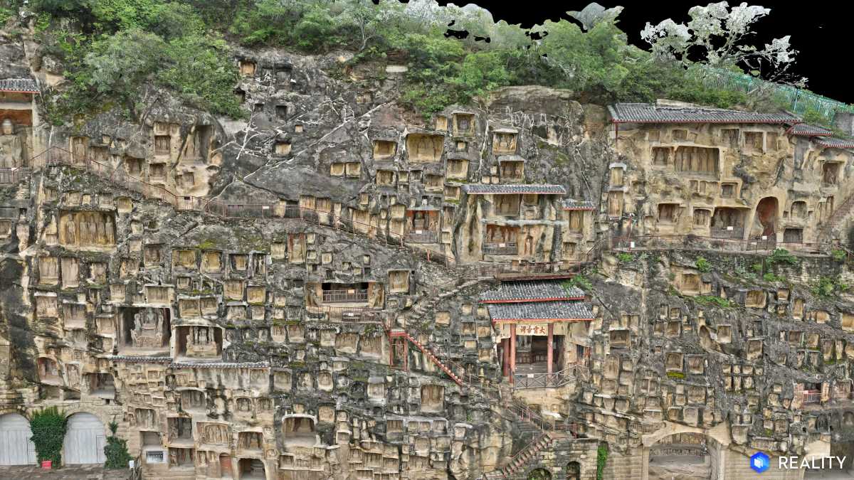
The software supports mesh models, point clouds, and 3D Gaussian Splatting (3DGS), allowing users to open and explore complex datasets instantly. More importantly, it removes typical access barriers: no login is required, installation is nearly instant, and deployment is lightweight enough for large teams.
That’s a big deal for industries like construction, surveying, and public safety, where sharing 3D data across teams, and with clients, can be a logistical headache.
By making the viewer completely free, DJI is also lowering the barrier to entry for smaller operators who may have previously avoided advanced 3D workflows due to software costs.
New: DJI confirms end-of-support timeline for Mavic 2 drone series
Built for speed and presentation, even at massive scale
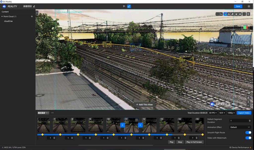
Performance is often the Achilles’ heel of 3D mapping tools, especially when dealing with large datasets. DJI Reality appears to directly address that challenge. The platform is optimized for smooth loading and lag-free navigation, even when working with large-scale models. Users can switch between perspective and orthographic views, display multiple models simultaneously, and browse projects across multiple windows.
It also supports stable rendering of massive scenes, including billion-point clouds and large mesh models, while maintaining strong frame rates, depending on hardware capabilities. This kind of performance matters in real-world scenarios, such as monitoring infrastructure projects or analyzing terrain data, where responsiveness can significantly impact productivity.
What sets DJI Reality apart from traditional viewers is its focus on presentation-ready output. The software includes features like:
- Path roaming, enabling guided fly-throughs of 3D environments
- Off-screen rendering with output up to 4K resolution
- Custom backgrounds and animation tools for polished visuals
These features allow users to turn raw mapping data into client-ready presentations without relying on third-party software. In practical terms, that means fewer steps between capturing data and delivering insights — something enterprise users increasingly demand.
Seamless integration across DJI’s ecosystem
DJI Reality isn’t a standalone product; it’s part of a broader ecosystem play. It integrates tightly with both DJI Terra and DJI Modify, creating a unified workflow:
Modeling → Optimization → Presentation
Users can jump from Terra’s reconstruction results into DJI Reality with a single click, preview models instantly, and save or roll back project files as needed.
Meanwhile, DJI Modify handles model cleanup and optimization tasks, like repairing mesh defects or smoothing point clouds, before the final presentation stage. Together, these tools form a full-stack solution that reduces reliance on third-party software while improving efficiency.
DJI Reality supports a wide range of formats, including:
- Mesh files (OBJ, B3DM)
- Point clouds (LAS, PNTS)
- DJI-specific formats like TerraGS
Users can drag and drop files, import entire folders, or load multiple models at once. The software is also compatible with models generated in DJI Terra (v3.7+) and DJI Modify (v1.1+), ensuring continuity across projects.
At launch, DJI Reality is available only on Windows, which may limit adoption among Mac-based teams.
The bigger picture: DJI’s software strategy
While DJI is best known for its drones, the company has been steadily expanding its software portfolio. Tools like DJI Terra already enable accurate 2D and 3D reconstruction using photogrammetry and LiDAR data, forming the backbone of many enterprise workflows. With DJI Reality, the company is now focusing on the final, and often overlooked, step: how that data is experienced.
It’s a smart move. As industries increasingly rely on digital twins and spatial data, the ability to quickly visualize and communicate complex models is becoming just as important as capturing them. By offering a free, high-performance viewer that plugs directly into its ecosystem, DJI is not just improving workflows; it’s making a strong case for keeping everything under one roof.
More: DJI pushes drones beyond cameras with AI competition
FTC: We use income earning auto affiliate links. More.


Comments