Drone navigation and situational awareness tech startup Kongsberg Geospatial is partnering with advanced radar specialist Echodyne to provide what they describe as enhanced, uncluttered piloting interfaces to facilitate the scaling of beyond visual line of sight operations (BVLOS).
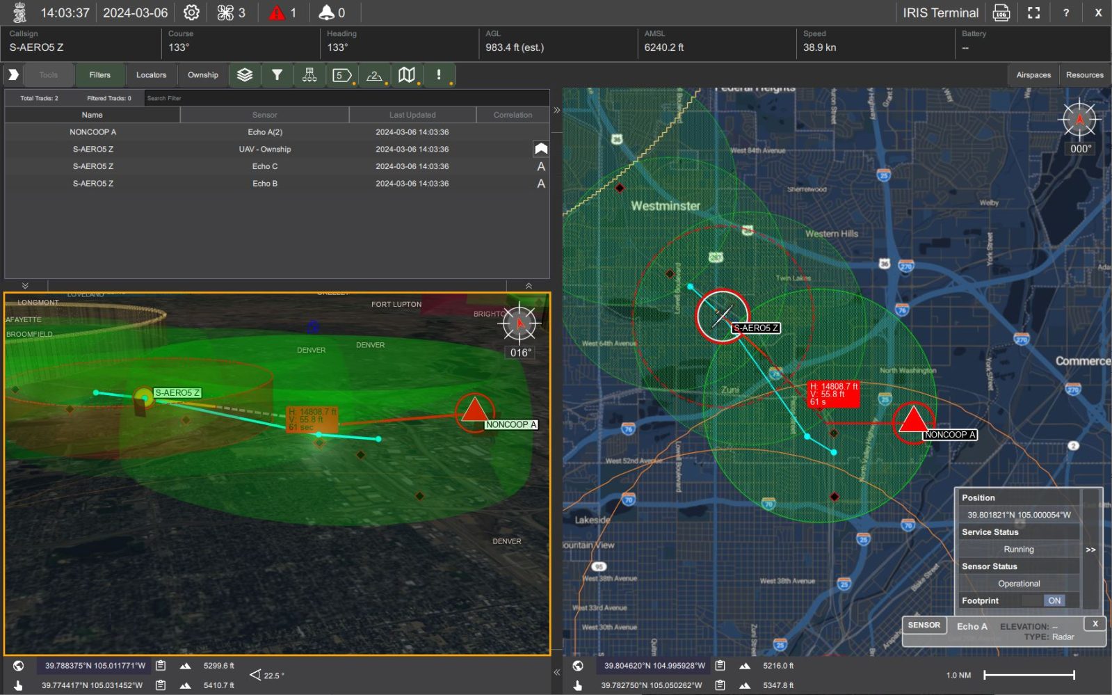
Ottawa-based Kongsberg Geospatial said the link-up provides users of its IRIS Terminal and IRIS ground control station airspace deconfliction solutions the data reinforcement of Echodyne’s patented metamaterials electronically scanned array (MESA) radars. The result, they say, is “an exceptionally detailed picture of airspace movement” for drone and other UAV operators, and an essential asset for the scaling of safe BVLOS flights.
The move makes Echodyne’s sophisticated radar performance available to civilian security and airspace management applications at commercial, off-the-shelf prices for the first time. The system, which was initially developed for security and military clients, will feed data to Kongsberg Geospatial’s second-generation IRIS systems, providing drone BVLOS and other operators with detect-and-avoid, sensor footprints, terrain awareness, and other potential conflict warnings.
Kongsberg Geospatial says Echodyne’s MESA radars provide exceptionally detailed pictures of airspace movements. Those feeds are said to strengthen IRIS tech that can handle multiple data streams simultaneously, offering BVLOS drone pilots unified, uncluttered airspace information to ensure safe and efficient mission completion.
“The benefits of combining market-leading data and spatial visualization capabilities with radar images showing such great detail of the airspace are enormous,” said Leo McCloskey, Echodyne’s vice president of marketing. “(A)pplications requiring BVLOS approvals need to present the safety case for comprehensive airspace situational awareness and this collaboration delivers that for customers.”
Kongsberg Geospatial IRIS ground control assets are autopilot agnostic, and enable multiple drones and sensor feeds to be monitored and controlled at once by a single operator. That clarity facilitates real-time calculation of distance between and trajectory of drones, which is critical to safe BVLOS activity.
“We couldn’t be more driven to forge this collaboration between two UAS industry leaders, and are excited about the BVLOS prospects to arise from this new relationship,” said Thomas Jimenez, market director for Kongsberg Geospatial.
FTC: We use income earning auto affiliate links. More.

Comments