
situational awareness

See All Stories

Kongsberg Geospatial, Echodyne pair to offer enhanced, uncluttered BVLOS drone tech

Kongsberg Echodyne BVLOS drone

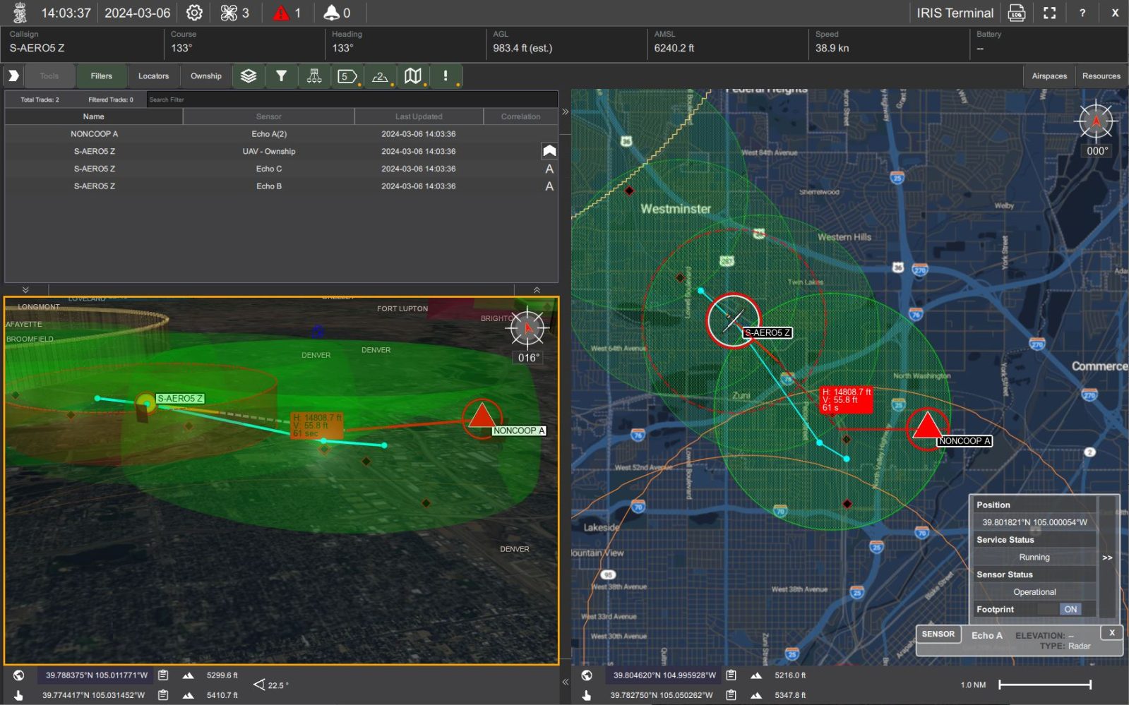
Drone navigation and situational awareness tech startup Kongsberg Geospatial is partnering with advanced radar specialist Echodyne to provide what they describe as enhanced, uncluttered piloting interfaces to facilitate the scaling of beyond visual line of sight operations (BVLOS).

Expand Expanding Close

FAA gives its B4UFLY drone app a post-Aloft upgrade, and new life [Update]

FAA drone B4UFLY

Though initially considered destined for the ash heap of history when its principal tech partner left the project, the essential drone pilot’s situational awareness and airspace restriction reference tool, B4UFLY, is getting new life from the Federal Aviation Administration (FAA) through an updated version of the app set for release next month.

Expand Expanding Close

BRINC to supply LEMUR 2 drones in $700K Schenectady police force deal

BRINC LEMUR 2 police

Seattle-based UAV security and emergency situational awareness specialist BRINC has recruited another big US client to its LEMUR 2 drone offer, with the New York city of Schenectady voting Tuesday to approve a nearly $700,000 contract with the startup to introduce the craft as police department asset.

Expand Expanding Close

AirSentinel makes drone ID app free to public safety units in DroneResponders partnership

AirSentinel DroneResponders public safety

Public safety and emergency response organizations using drones in their work will find it easier – and much less expensive – to monitor the airspace around them during their work thanks to a new partnership between UAV remote identification tech specialist AirSentinel, and the nonprofit DroneResponders association.

Expand Expanding Close

Using drone 3D models to track team members during live missions

drone track team members tacbrowse 3d model skyebrowse

One-click reality capture platform SkyeBrowse has launched a new situational awareness tool that allows for real-time tracking of team members within a drone 3D model. In other words, you create a 2D or 3D model of an area in less than five minutes using a single drone video, and participating members can plot their GPS coordinates onto that model in real time.

Expand Expanding Close

Manage push notifications

notification icon
We would like to show you notifications for the latest news and updates.
notification icon
Please wait...processing
notification icon
We would like to show you notifications for the latest news and updates.
notification icon
Please wait...processing