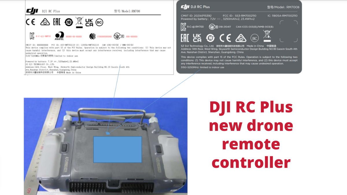
Author

Avatar for Ishveena Singh

Ishveena Singh

IshveenaSingh

Ishveena Singh is a versatile journalist and writer with a passion for drones and location technologies. She has been named as one of the 50 Rising Stars of the geospatial industry for the year 2021 by Geospatial World magazine.

Connect with Ishveena Singh

Lithuania is deploying drones to detect potholes and inspect road damage

drones road damage inspect

Lithuania is looking to drones to improve the quality of its road infrastructure. AB Kelių priežiūra, a state-owned company that ensures the maintenance of almost 13,050 miles (21,000 km) of national roads, is teaming up with drone manufacturer Thrust and tech company Agmis to automate road inspections with flying machines and artificial intelligence.

Expand Expanding Close

Lumicopter makes confined-space inspection more accessible with DJI FPV drone

lumicopter

Singapore-based drone solutions company Avetics Global says it’s set to make confined-space inspection more accessible with an affordable new product, Lumicopter. Combining the DJI FPV drone with a custom-made protective shell and LED light, Lumicopter has been designed to fly in enclosed or hazardous facilities such as storage tanks, building interiors, powerplants, ships, etc.

Expand Expanding Close

Shot entirely on drones, this award-winning ski film is a must-watch

ski dji drones

Named the best international short ski film of 2021 at High Five Ski Film Festival, FLOW captures world-class freeride skier Sam Favret’s recent adventures (on empty slopes, no less!) amid COVID-19 lockdowns. The mind-blowing film is made 100% from aerial footage – using FPV drones, DJI Inspire 2 with Zenmuse X7, and DJI Mavic 2 Pro. It showcases the majestic beauty and high-intensity action of skiing Europe’s famed Chamonix-Mont-Blanc in such a grand manner that you simply must take out a few minutes to watch it now.

Expand Expanding Close

Israel allows drone to fly in civilian airspace in a world first

israel drone civilian airspace

Israel has created aviation history by approving a drone to fly in civilian airspace and not restricting its flight to uncontrolled airspace. Following its certification by the Civil Aviation Authority of the State of Israel (CAAI), the Hermes Starliner UAS by Elbit Systems will now be able to fly at medium altitudes for a multitude of long-range missions, such as securing mass public events, environmental inspection missions, precision agriculture work, maritime search and rescue, as well as border security and anti-terror operations.

Expand Expanding Close

FAA grants BVLOS drone waiver for a 12-mile distance, its longest ever

faa bvlos waiver

Drone solution providers Censys Technologies and Soaring Eagle Technologies have secured a fresh beyond visual line of sight (BVLOS) waiver from the Federal Aviation Administration (FAA). This waiver covers a 12-mile distance, which the companies stress is the longest distance ever approved by the FAA.

Expand Expanding Close

Port of Antwerp uses drones to keep docks free of floating waste

port antwerp drones waste

About 50 tons of floating debris – plastics, wood, cardboard, organic material, mooring lines – are collected every year from the docks in Belgium’s port of Antwerp. Not only does this waste pollute the waters, but it also has an impact on biodiversity and can cause damage to ships. This is why port authorities are now turning to drones to detect and clean up the debris as soon as possible.

Expand Expanding Close

Drone maps ‘at risk’ 15th-century monument in brick-by-brick detail

DJI p1 camera

The Bondgate Tower in Northumberland, UK, is a 15th-century monument that is in danger of collapse, and as such, sits on the “Historic England’s Heritage At Risk” register. As part of conservation efforts, the historic gatehouse was recently mapped using a drone, and the results are so incredible, you need to see them for yourself.

Expand Expanding Close