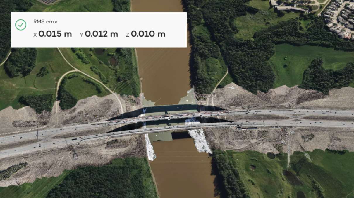
surveying and mapping

See All Stories

Skyports’ drones aid Network Rail with biodiversity-protecting infrastructure maintenance

skyports drone rail

UK companies Skyports Drone Services and environmental protection maintenance specialist Ground Control are pairing up to help railroad infrastructure owner Network Rail in spotting and organizing its track clearing activities with greater attention to ecological protection.

Expand Expanding Close

Let my gimbal go: NC court case argues drone mapping, surveying is free speech

drone surveying

The effects of drone technology have been sufficiently disruptive – or perhaps “threatening” is a better term – to legacy land surveying officials that a North Carolina aerial imaging and mapping service provider is now having to defend attacks on his activity with arguments it’s a form of free speech protected by the First Amendment.

Expand Expanding Close

New survey-grade drone camera comes with a 128MP sensor

phase one p5 128mp drone camera

Phase One, a Denmark-based company specializing in digital imaging tech, has unveiled a fantastic new survey-grade camera that boasts an advanced 128MP image sensor. Developed in collaboration with Quantum Systems and Trimble, the Phase One P5 integrates seamlessly with Trinity Pro fixed-wing mapping drone and Trimble Business Center construction and modeling software.

Expand Expanding Close

Flyability unveils new LiDAR payload for Elios 3 indoor drone

Flyability indoor drone lidar elios 3 payload surveying signal loss

Confined spaces and indoor drone specialist Flyability has released a new LiDAR surveying payload for the Elios 3. Available as part of a bundle including training, reflective targets, and specialized processing software, FARO Connect, Flyability’s new Ouster OS0-128 Rev 7 payload is designed for safe, centimeter-accurate scans of hard-to-reach areas.

Expand Expanding Close

Soaring Eagle gets FAA drone BVLOS waiver for unlimited distance inspections

Soaring Eagle BVLOS drone

Drone data collection, surveying, and infrastructure inspection company Soaring Eagle Technologies has added another Federal Aviation Administration (FAA) beyond visual line of sight (BVLOS) waiver to its collection – this one permitting virtually unlimited geographic range of mission operation.

Expand Expanding Close

Alumnus of Oz’s SheMaps uses drone to preserve Aboriginal traditions

Aboriginal drones

Score another drones-for-good point for Australia’s UAV and geospatial education provider SheMaps, whose aerial tech introduction and training have led a young Queensland woman to take to the skies in an effort to safeguard the history of the Aboriginal Koko-Muluridji people’s Wallara clan.

Expand Expanding Close

Overhead Intelligence and Iris Automation avionics enable EVLOS-BVLOS drone surveys

Overhead Intelligence Iris Automation BVLOS

Aerial geophysical mapping specialist Overhead Intelligence has used a drone equipped with Iris Automation safety avionics tech to operate a combined extended visual line of sight (EVLOS) and beyond visual line of sight (BVLOS) magnetometer survey mission over a wide area of Canadian mineral deposits.

Expand Expanding Close

Aussie company teaches drones in school to remedy a worsening surveyor shortage

drone surveyor

Australia and its ever-booming economy are being hampered by its construction sector suffering from continued pandemic fallout, supply chain disruption, rising material prices, and a deepening shortage of skilled labor. As a remedy to that latter problem, a national education business is using drone technology in classroom-level instruction to encourage students to navigate those aerial assets into surveying careers.

Expand Expanding Close

Manage push notifications

notification icon
We would like to show you notifications for the latest news and updates.
notification icon
Please wait...processing
notification icon
We would like to show you notifications for the latest news and updates.
notification icon
Please wait...processing