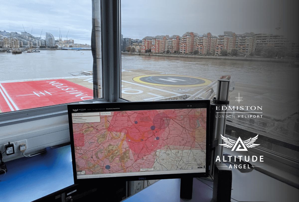
Author

Avatar for Ishveena Singh

Ishveena Singh

IshveenaSingh

Ishveena Singh is a versatile journalist and writer with a passion for drones and location technologies. She has been named as one of the 50 Rising Stars of the geospatial industry for the year 2021 by Geospatial World magazine.

Connect with Ishveena Singh

New Insta360 thumb-sized camera arrives next week — is it GO 3?

new insta360 go 3 camera buy price

Editor’s update [June 27, 2023]: The new Insta360 GO 3 camera is now available to buy with prices starting at $380. The product is also available to buy on Amazon with next-day delivery in many cities.

Insta360, the maker of highly versatile yet ultra-portable 360-degree cameras, has dropped a new teaser for a product it says will bring about a “tiny revolution.” And it could very well be the GO 3!

Expand Expanding Close

Strix2100 universal drone docking station rolls out from Ohio

Strix universal drone docking station

It looks like Spright, the drone services division of air medical service provider Air Methods, is set to receive what is being called the only universal and fully autonomous drone docking station in the world. Israel-based StrixDrones tells DroneDJ that the first units of its highly advanced Strix2100 DroneDock are now rolling off the assembly line in Dayton, Ohio.

Expand Expanding Close

EASA and Brazil’s ANAC partner on air taxi certification

Eve eVTOL UAM Embraer easa anac air taxi certification

With the recent increase in activities related to advanced air mobility (AAM) using electric vertical takeoff and landing (eVTOL) aircraft to move people and cargo between places, national regulators are also finding ways to coordinate a safe and harmonized introduction of new technologies in the civil aviation system. The latest development in this direction comes from the European Union Aviation Safety Agency (EASA).

Expand Expanding Close

Drone 3D model platform SkyeBrowse now accepts videos from phone, GoPro

phone video 3D modeling skyebrowse

Want to convert your phone video into a 3D model? One of the fastest and easiest drone reality capture platforms out there, SkyeBrowse, has just updated its proprietary videogrammetry software to make this possible! In addition to DJI and Autel aircraft, SkyeBrowse now supports raw video files from all drones, phones, GoPro, and video cameras.

Expand Expanding Close

Infrastructure bill proposes $100M in grants for US-made drones

Dominion Skydio drones BVLOS inspection

Senators Jacky Rosen (D-Nev.), John Boozman (R-Ark.), and Richard Blumenthal (D-Conn.) have proposed new legislation to increase the use of US-made drones in infrastructure projects. The bipartisan bill would authorize $100 million in competitive grants to help local governments leverage American drones in critical infrastructure inspections, maintenance, and construction activities.

Expand Expanding Close

Drone flies 77 miles nonstop in Texas, live-streaming video

valmont drone bvlos longest tmobile 5g inspection

Infrastructure inspections are a routine task for businesses like Valmont Industries. But a recent mission from Valmont is making headlines because it saw the company flying a gas-electric hybrid drone nonstop for 77 miles! The drone flew for almost three hours, from Childress to Aspermont in Texas, inspecting vital infrastructure like power lines, railroads, bridges, and more.

Expand Expanding Close

MIT-founded drone company launches home delivery service in Norway

norway drone delivery aviant kyte

Drone logistics company Aviant has announced the launch of its home delivery service, Kyte. Drones will now deliver groceries, takeaway food, and non-prescription medicines to sparsely populated areas and vacation homes in Norway. In addition, Aviant has landed $1 million in funding from Innovation Norway to autonomously deliver vital prescription medicines directly from pharmacies to people in remote and suburban areas.

Expand Expanding Close

New US state maps, critical firmware update for Teledyne FLIR SIRAS drone

teledyne flir siras drone firmware update map download

A couple of important updates for SIRAS drone operators. New US state and regional maps are now available to download for the IP54-rated professional drone. In addition, Teledyne FLIR has released a safety-focused firmware update for the SIRAS to address a potential issue affecting the communication between the drone and its remote controller.

Expand Expanding Close